
With a unique understanding of environmental surveying through experience, Doyle and Wachtstetter Inc. is well versed in the field of providing land surveying services to support environmental professionals. From wetlands delineation to environment remediation, documenting and mapping monitoring wells to restrictive covenants for property management we maintain the technology and personnel to support complex projects.
*Our environmental surveying services have been broken down into categories to aid in viewing, if you have something particular in mind you can browse through or use the search bar at the top of the page to locate keywords, in the case you have any questions or uncertainties please press the "Contact us" button at the bottom of the page and we can assist you directly.
Services

Engineering and Design:
Preliminary Site Information, Pre and Post Construction Comparison, Engineering Design Verification, Accurate Information for Construction Monitoring, Experienced Construction Site Professionals, Precision Data for Design Calculations, Current Conditions, Elevation Data, Improvements, Stockpile Surveys, Drainage and Utility Mapping and Design, Data Projection Conversions for Local and Geodetic Datasets.

Aerial Imaging & Data Acquisition:
FAA Compliant, High Resolution Aerial Photography, Visual, LiDAR, Geospatial Applications, Up to Date Actionable Information, GIS Mapping, 3D Modeling, Geomatics, Photogrammetry, Aerial Data Integration, Survey-Grade Geographic Information with Reduced Acquisition and Processing Time.

Construction:
Design and Infrastructure Monitoring, Professional Construction Services, Commercial, Industrial, Petrochemical Down-Stream Operations, Chemical Plants and Tank Farms, Precision As-Built and Layout/Staking Services, Stockpile and Land Volumes, Project Consulting and Design, Permitting, Design and Tolerance Verification, Preliminary and Post-Construction Equipment and Progress Monitoring.

Commercial Land Surveys:
American Land Title Association (ALTA), American Congress of Surveying and Mapping (ACSM), Certified National Society of Professional Surveyors (NSPS), Right-of-Way, Easement, Pipeline, Oil & Gas Lease, Drill & Well Layout and Location, Telecommunication and Electrical Transmission, Subdivision Platting, Boundary Disputes and Encroachments, Design and Existing Volume Calculations for Grading and Removal.

Topographic:
Existing and Design Calculations, Ground Contour information, Elevation Mapping and Planning Services, Site Plans and Drawings, Cartography, Improvement Locations, Proposed Construction, Design Preparation, Terrestrial or Hydrographic Information for Permitting or Design.

GIS/LIS:
Geographic Information Systems and Services, Land Information Science, Containment Volume and Drainage Studies, Spatial Imaging or Terrain Modelling, Laser Scanning and 3-Dimensional Data for Realistic Visualization and Virtual Representation, Computer Assisted Drafting (CAD) Services, Processing Geospatial Data, Geo-Referenced Spatial Data.

Geospatial Acquisition & Analysis:
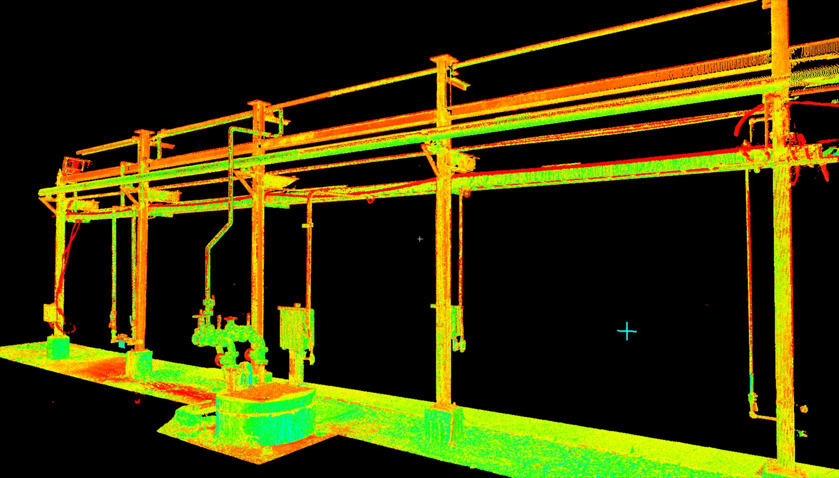
Customized Solutions for Diverse Data, Remote Sensing, Gathering and Collection, 3D Models for Engineering, Design and Analysis, Hazardous Environment and Material Solutions, High Definition Scanning (HDS), Light Detection and Ranging (LiDAR) Surveying, Processing, Management, Conversion & Manipulation of Historical and Current Satellite Imagery and Geographic Spatial Data, High Accuracy/Low Tolerance Studies, Site Imagery, Professional Support and Expertise, Spatial Analysis and Modeling.
Hydrographic:
Specialized Bathymetric and Topographic and Mapping Surveys, Pipeline Maintenance, Single and Multi-beam Sonar, Maritime Construction and Dredging, Tidal Control Surveys, Beach and Waterway Profiling, Wetland Mapping and Deliniation, Bridge and Reserviour Inspections, Geophysical Surveys, Sub-Bottom, Magnetometer and Gradiometer.